Perspectives
Practical insights and opinions from agriculture and natural resources experts—brought to you by the Center for Sustaining Agriculture and Natural Resources.
The Columbia Basin Irrigation Project: As Drought-Proof and Sustainable as it Gets
By Andrew McGuire, CSANR Senior Extension Fellow
Irrigation Systems and Food Production
Irrigated agriculture is critical, supplying 40% of the world’s food despite having only 28% of cropland. Irrigation also stabilizes food production by separating crop yields from the risk of variable rainfall (Troy et al., 2015). However, history reveals that most irrigation systems eventually fail. In Pillar of Sand, Sandra Postel discusses how irrigation-dependent civilizations collapsed due to these shared failure factors (Postel, 1999; Elias et al., 2023):
- Changes in water supply
- Sedimentation
- Salinization of the soil
- Failure to maintain the system
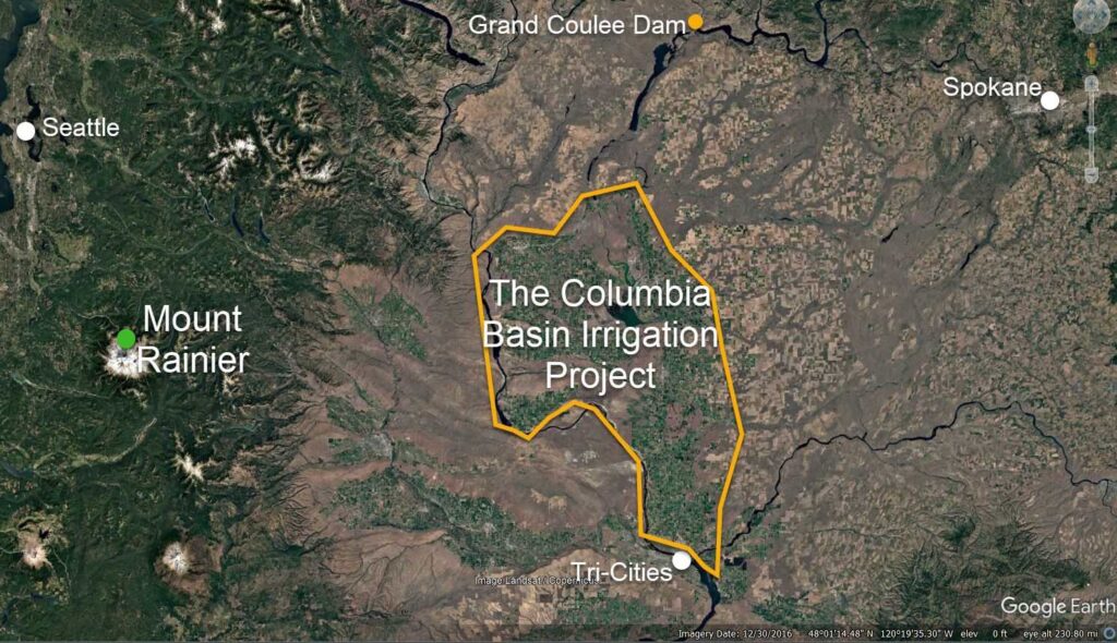
Modern irrigation systems face these same challenges. Drought, water scarcity, and soil degradation are on the rise. And climate change is expected to quadruple seasonal heat and rainfall variability by 2040, threatening the stability of crop yields (Troy et al. 2015; Walker et al., 2019). The Columbia Basin Irrigation Project (CBP) in Washington State has been producing food for over 70 years, but can that be sustained? Or will it fail from the same challenges that took down other irrigation systems? This analysis examines CBP’s sustainability by assessing its resilience to the four primary threats that have affected irrigation systems globally.

Threats to Irrigation Systems
Threat 1: Inadequate Water Supply
“In Washington State, overall vulnerability of agricultural production to a changing climate is expected to be low in the Columbia Basin Project where irrigation water supplies are available.”
(Snover et al. 2013)
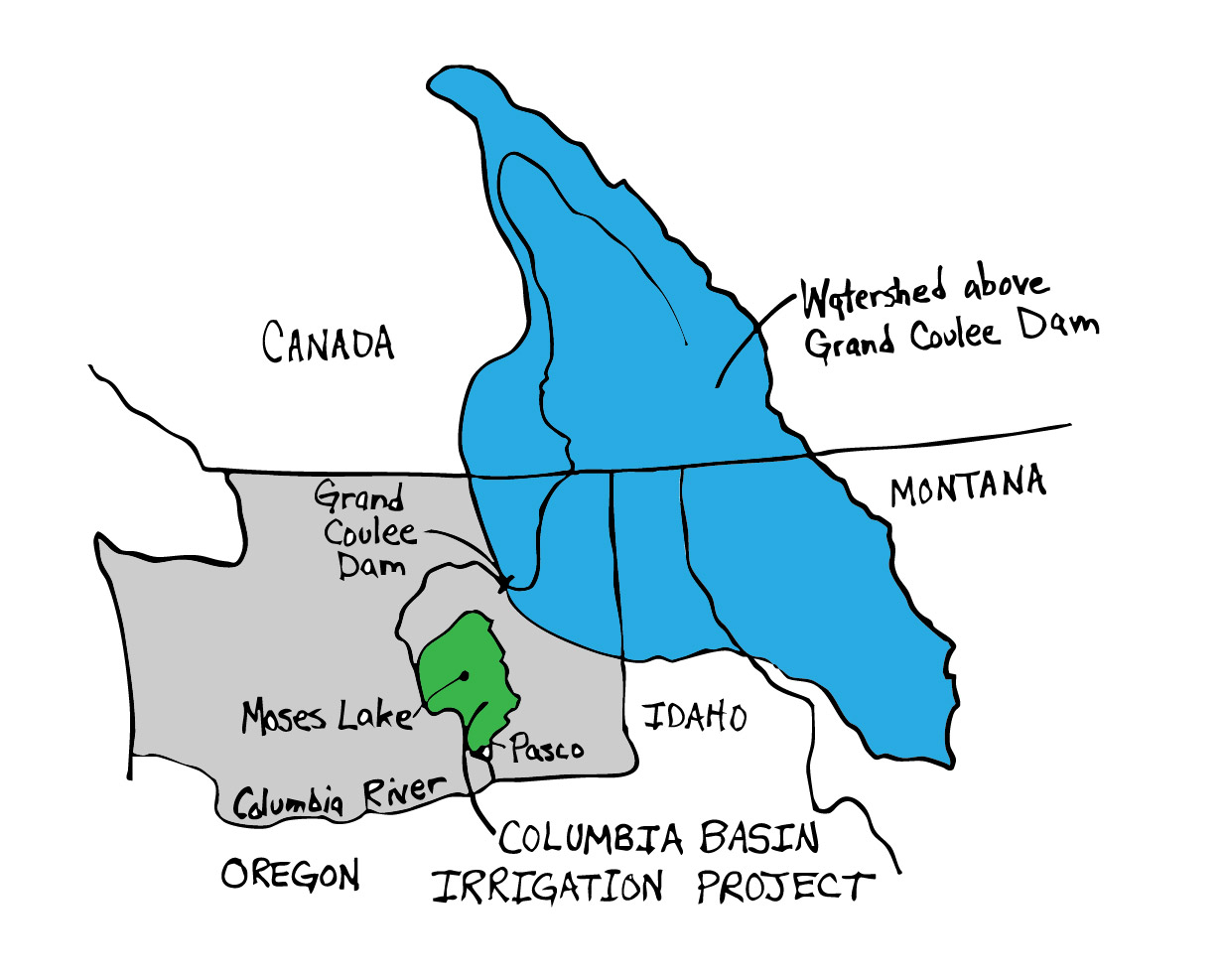
Inadequate water supply remains the most common cause of irrigation failure, often due to drought, water use beyond supply limits, or climate impacts (Postel, 1999). The CBP benefits from a large, stable water source, the Columbia River, with a watershed that extends into the Canadian Rockies (see Fig. 1). Although still affected by climate change (Intsiful and Ambinakudige, 2021), its northerly location and high elevation make it less vulnerable to drought impacts seen elsewhere, such as in the Southwest United States (Qin et al. 2020). The water flow outlook for the upper Columbia River remains favorable, with an expected shift to earlier peak flows but also a slight increase in annual flow (Hall et al., 2022).
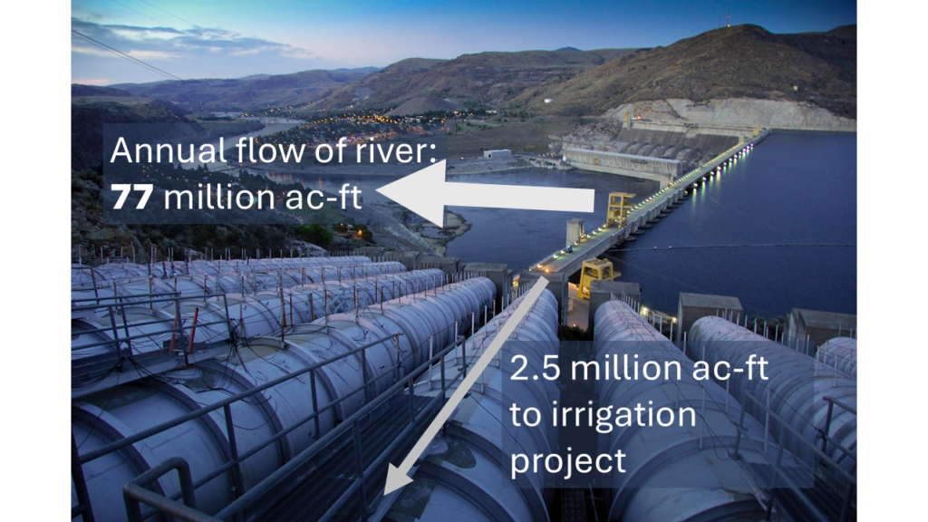
Given this large watershed, the water used by the CBP is small compared to the flow of the river. It currently draws an estimated at 2.4 million acre-feet at Grand Coulee Dam, which is only 3% of the Columbia River’s average annual flow (Figure 3). Furthermore, in drought years, Lake Roosevelt—backed up behind Grand Coulee Dam— buffers against shortages by storing three times the project’s annual water use. Finally, the project has priority water rights, dating back to 1938 (Weber and Lee, 2021) all but guaranteeing sufficient water quantity. These advantages of the CBP water supply (Rajagopalan et al., 2018) are in stark contrast to the irrigated cropland in California, Arizona, and even in the Ogalla aquifer of the US High Plains (Schoups et al. 2005; Walker et al. 2019; Elias et al. 2023). The Columbia Basin Irrigation Project is a drought-proof as it gets.
Threat 2: Sedimentation
Sedimentation, or silt buildup, is a threat that slowly decreases water storage behind dams and impedes water flow in irrigation canals and ditches. While rivers like the Colorado carry a high load of sediment, the Columbia River, especially in the upper reaches, carries less (Figure 7). The US Bureau of Reclamation estimates that sedimentation since 1942 has reduced water storage behind Grand Coulee dam by about 10% (Ferrari, 2012). Sedimentation in the canals and ditches is removed each year by local Irrigation districts. As with inadequate water supply, the threat of sedimentation for the CBP is low.
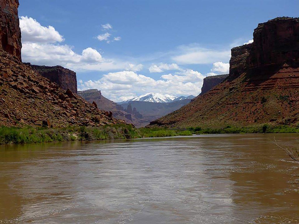
Figure 5. The Colorado River (left) has a much higher sediment load than the upper Columbia River (right). This limits the risk of sedimentation and associated decreases in water storage capacity and conveyance. USFWS Mountain-Prairie photo, NPS photo, Public domain, via Wikimedia Commons.
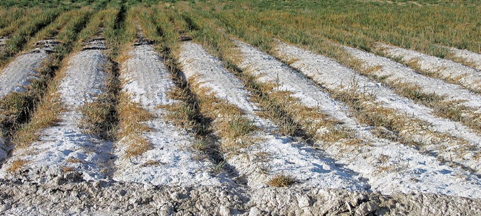
Threat 3: Soil Salinization
Soil salinization, where the soil loses productivity due to accumulating salts, devastates many irrigation systems over time, including at least 14 million acres in the US (Short, 2019). Soil salinization occurs when salt in the irrigation water remains in the surface soil after the water evaporates or is used by crops. If the salt is not leached out, it builds up to levels that hinder soil function and decrease crop yields. Since the only way for salt to leave the soil is through water, the problem is worsened by poorly drained soils.
In irrigation systems along the Colorado river, high salt levels in the river water are the main problem. Salinity levels in the Colorado range from 723 mg/L at Hoover dam to 879 mg/L further downstream (Morford, 2014). In contrast, the water in the Columbia River at Grand Coulee Dam is very low in salts, ranging from 70-85 mg/l (McKillips and Wells, 2007), far below the irrigation limit of >525 mg/l (Fipps, 2003).
In California, drainage is the primary driver of soil salinization in irrigated cropland (Schoups et al. 2005). In the CBP, soon after irrigation water was first delivered, project managers recognized the need to provide drainage for some fields. An extensive drainage system was eventually installed with more than 2,845 miles of drains (Storey, 2008). This effectively removed most drainage problems from project cropland.
With both high-quality water and good drainage of irrigated soils, the risk of salinization to the Columbia Basin irrigation project is low.
Threat 4: Infrastructure Maintenance
The last threat to irrigation systems is insufficient maintenance of the infrastructure. To function efficiently, irrigation systems require well maintained water conveyance components: the dam, pumps, reservoirs, canals, siphons, and ditches. Failure of any one of these components poses significant risks to an irrigation project, and a lack of resources or organization can accelerate system decline. The CBP has seen serious incidents that test this maintenance challenge. In 2014, a crack in Wanapum Dam (provides hydropower for the pumps and sprinkler irrigation systems of the CBP) required immediate repair, which was completed by temporarily lowering the water level and funding a $61 million fix, ultimately covered by local Public Utility District ratepayers. Earlier in 2024, a main canal sidewall failed during the irrigation season, but repairs were completed within a week, minimizing impact on crop production.
Although not a factor for ancient irrigation systems, maintenance of legal infrastructure is also important to maintain. As water scarcity becomes more acute in regions, conflicts between countries over shared water resources can occur. For the CBP, a new proposed Columbia River Treaty with Canada is now awaiting approval of the US and Canadian governments. This treaty ensures that the water flowing from Canada will continue to flow for the benefit of both countries.
Irrigation project maintenance requires a commitment from society, from the people that live here, and from those that eat the food produced here. As far as I can tell, project maintenance is not a current threat to the irrigation system.
The Future of the Columbia Basin Irrigation Project
Maintaining irrigated cropland is crucial for current and future food security (Walker et al., 2019). Current trends, however, show irrigation systems are susceptible to the same threats that have caused them to fail throughout history. The CBP is not one of them.
Within the limited scope of this analysis, and in view of other irrigation systems, I conclude that the Columbia Basin irrigation project is as sustainable as it gets. With dependable water sources, limited sedimentation, low risk of soil salinization, and responsive infrastructure maintenance, the CBP is a sustainable irrigation system in a world where many systems are faltering. The project’s continued productivity not only supports regional food security but contributes to national food supply stability. If we continue to support it, the Columbia Basin Project should continue to provide a reliable supply of food in the foreseeable future.
Please contact me if you would like me to make a presentation on this topic.
All Perspectives from Andrew McGuire
References:
Elias, E., T. Tsegaye, C. Hapeman, K. Mankin, P. Kleinman, et al. 2023. A vision for integrated, collaborative solutions to critical water and food challenges. Journal of Soil and Water Conservation 78(3): 63A-68A. doi: 10.2489/jswc.2023.1220A.
Ferrari, R. 2012. Franklin D. Roosevelt Lake – Grand Coulee Dam 2010-11 Survey. Technical Survey. https://www.usbr.gov/tsc/techreferences/reservoir.html
Fipps, G. 2003. Irrigation water quality standards and salinity management strategies. Texas FARMER Collection. Online Access (accessed 16 August 2024).
Hall, S.A., Adam, J.C., Yourek, M.A., Whittemore, A.M., Yorgey, G.G., Scarpare, F., Liu, M., McLarty, S., Asante-Sasu, C., McClure, S., Turk, J., Haller, D., Padowski, J., Deshar, R., Brady, M.P., Rajagopalan, K., Barber, M.E., Weber, R., Stockle, C.O., Goodspeed, H.L., Gustine, R.N., Kondal, A., Yoder, J., Deaver, B., Downes, M., Tarbutton, S., Callahan, M., Price, P. Roberts, T., Stephens, J., and Valdez, W. 2022. 2021 Columbia River Basin Long-Term Water Supply and Demand Forecast Technical Report. Washington Dept. of Ecology.
Intsiful, A., and S. Ambinakudige. 2021. Glacier Cover Change Assessment of the Columbia Icefield in the Canadian Rocky Mountains, Canada (1985–2018). Geosciences 11(1): 19. doi: 10.3390/geosciences11010019.
McKillip, M.L., and S. Wells. 2007. Lake Roosevelt Water Quality and Hydrodynamic Model Calibration with Fish Bioenergetics. Portland State University, Civil and Environmental Engineering Department.
Morford, S. 2014. Salinity in the Colorado River Basin. Bureau of Reclamation. Phoenix, AZ.
Postel, S. 1999. Pillar of Sand: Can the Irrigation Miracle Last? W. W. Norton & Company, New York.
Qin, Y., J.T. Abatzoglou, S. Siebert, L.S. Huning, A. AghaKouchak, et al. 2020. Agricultural risks from changing snowmelt. Nat. Clim. Chang.: 1–7. doi: 10.1038/s41558-020-0746-8.
Rajagopalan, K., K.J. Chinnayakanahalli, C.O. Stockle, R.L. Nelson, C.E. Kruger, et al. 2018. Impacts of Near-Term Climate Change on Irrigation Demands and Crop Yields in the Columbia River Basin. Water Resources Research 54(3): 2152–2182. doi: 10.1002/2017WR020954.
Schoups, G., J.W. Hopmans, C.A. Young, J.A. Vrugt, W.W. Wallender, et al. 2005. Sustainability of irrigated agriculture in the San Joaquin Valley, California. Proc Natl Acad Sci U S A 102(43): 15352–15356. doi: 10.1073/pnas.0507723102.
Short, H.L. 2019. Saline Soils and the Agricultural Failure of a Prehistoric Population. Journal of Environmental Quality 48(6): 1652–1663. doi: 10.2134/jeq2019.01.0015.
Snover, A.K., G.S. Mauger, L.C. Whitely Binder, M. Krosby, and I. Tohver. 2013. Climate change impacts and adaptation in Washington state: Technical summaries for decision makers. State of Knowledge Report prepared for the Washington State Department of Ecology. Climate Impacts Group, University of Washington, Seattle.
Storey, B.A. 2008. The Bureau of Reclamation: History Essays from the Centennial Symposium. Government Printing Office.
Troy, T.J., C. Kipgen, and I. Pal. 2015. The impact of climate extremes and irrigation on US crop yields. Environ. Res. Lett. 10(5): 054013. doi: 10.1088/1748-9326/10/5/054013.
Walker, S., R.W. Hofste, and L. Schleifer. 2019. Water Could Limit Our Ability to Feed the World. These 9 Graphics Explain Why. Online Access (accessed 16 August 2024).
Weber, E., and B. Lee. 2021. Columbia basin project water authorizations. The Water Report.
Comments
Great article, Andy, I share your conclusion. The one place i wonder if there is more risk is low summer flows, which are projected to get lower over time with less snowpack. What percent of the river flow in August, for example, is taken by the CBP, and is this big enough to lead to conflicts with fish, hydropower, other uses?
Hi David. Good to hear from you!
I agree, August would be the period where low river flows and high irrigation demand might pose some risk. I don’t know the withdrawal rate then compared to river flows but will try to find it. I do wonder if the large storage capacity of Lake Roosevelt might fully or partly mitigate the problem.
David, I found the data after Sonia directed me to a USGS website, https://www.usgs.gov/centers/washington-water-science-center/data.
I pulled the average monthly surface water flows for the Feeder Canal and the River at Grand Coulee, from 2000-2023. For August, the feeder canal averaged 5700 ft3/s in August while the river was at 103,000, so the project was pulling about 5.5%. But the max flow for irrigation occurs in July (I think longer days in July overcome the higher temps at the beginning of August, and this is confirmed by my lawn irrigation calculations). In July: Irrigation canal: 8430, River: 126,000, or 6.7%. I am not sure about fish/hydropower and other needs, but this remains a low percentage of the river’s flow.
Actually, September is when the irrigation water withdrawals peak as a percentage of the river flow. That is the month with minimum flow in the river and still enough irrigation water being taken out to get up to 9% of the river’s flow.
Thanks, Andy, for continuing to produce some of the best and most useful articles anywhere.
Stewart, thanks for the comment. I am glad you find them useful.
Hello, I am a farmer in the Hiawatha Valley area of Moses Lake Washington. I am in block 89 Farm unit 183.02! I’m look for any information pertaining to the topographical lay of the land referring to- in the beginning When the Columbia basin was laid out for rill irrigation and all the head gates or Water Weirs were placed at the high points of all the laterals or water delivery points for each unit? Can you help me with this information or point me in a good direction, thank you – Les
Hi Les. Unfortunately, we do not have that type of information in our local Extension office.
I would contact the irrigation district first, and then if they cannot help you, the Bureau will of Reclamation in Ephrata might have that information.
Hope you find what you are looking for.